

Where does Dar’s floodwater go?
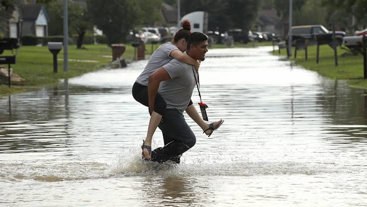
DAR ES SALAAM: WHEN dark clouds gather over Dar es Salaam, residents in low-lying neighbourhoods do not only watch the sky; they watch the drains, rivers and roads, knowing that a few hours of heavy rain can quickly turn familiar routes into waterways.
For a city whose population and built-up areas have expanded rapidly, flooding has become more than a seasonal inconvenience. It raises a fundamental question: When rain falls on Dar es Salaam, where does the water go?
The question is becoming more urgent as the Tanzania Meteorological Authority (TMA) forecasts a strong El Niño influence during the October, December 2026 rainfall season, with above-normal to normal rainfall expected in many parts of the Northern Coast, including areas around Dar es Salaam.
TMA has warned of possible flooding, rising water levels in rivers and dams, and damage to roads and bridges, putting greater attention on the city’s preparedness before the rains intensify.
Speaking to the Daily News, Saint Augustine University of Tanzania (SAUT) climate researcher, Mr Ngongo Mang’enyi, said geography plays a major role in making Dar es Salaam and other areas vulnerable to heavy rainfall.
He said coastal areas experience high atmospheric moisture from the Indian Ocean, while warmer ocean waters increase evaporation and provide more moisture for rainfall.
“Winds from the southwestern and southeastern directions carry this moistureladen air from the Indian Ocean towards the Tanzanian coast, where it encounters cooler air and produces heavy rainfall,” he said.
The explanation points to the first part of Dar es Salaam’s flooding problem: The city cannot control how much rain falls, but it can determine how effectively that water is captured, channelled and discharged.
That is where the city’s deeper challenge begins. The Tanzania Rural and Urban Roads Agency (TARURA) says preparations are already underway.
TARURA Chief Executive Officer, Engineer Victor Seff, said the agency had issued operational guidelines to regional and district managers following weather advisories, directing them to prepare drainage infrastructure before the rains intensify.
“We have already issued operational guidelines to ensure full readiness for the expected rains as advised by the Meteorological Authority. We have instructed regional and district managers to ensure all drains and culverts are cleared so that storm water can flow safely,” he said.
But the challenge facing Dar es Salaam goes beyond blocked drains. According to Eng Seff, the city’s storm-water problem is partly rooted in the way urban development has interacted with its natural drainage system.
Natural streams and waterways that once carried rainwater have, over time, been affected by settlement and subdivision of land.
He said some natural streams were historically divided into residential plots, obstructing the routes through which water would naturally flow.
That leaves the city with a difficult equation: More buildings, roads and paved surfaces generating runoff, but fewer unobstructed natural channels and drainage routes to carry the water away.
The scale of the challenge is reflected in the work of Ramani Huria, a community mapping initiative that has mapped 29 wards and neighbourhoods selected because they encompass some of Dar es Salaam’s flood prone areas.
The mapping covered waterways, roads and vulnerable communities to support disaster planning and response.
Kigogo, for example, has extensive areas exposed to flooding, with settlements along river valleys, solid waste blocking waterways and inadequate drainage among the documented problems. Tandale has similarly experienced flooding linked to blocked drains and low-lying areas along the Ng’ombe River.
The Msimbazi Valley remains one of the clearest examples of how rainfall, settlement, infrastructure and drainage intersect. It is also where some of the city’s most significant flood-control interventions are being concentrated.
Dar es Salaam Regional Commissioner, Albert Chalamila, said the region had intensified preparations for the expected rains, drawing lessons from the heavy rainfall experienced in 2024.
He identified inadequate drainage, human activities obstructing natural waterways and indiscriminate disposal of waste as some of the challenges that could worsen flooding.
“The region has agreed with district commissioners, directors and other officials to conduct public awareness campaigns, particularly among people living in valleys and other vulnerable areas, so that they can take early action and remove waste and other obstructions that could hinder the flow of water,” he said.
For the Regional Commissioner, the response cannot begin when floodwater is already inside homes. It has to start by clearing the routes that water needs to use.
He said the region was working with institutions responsible for river-basin management to clean rivers, remove obstructions and increase the capacity of waterways to carry large volumes of water during heavy rainfall.
That approach is being matched with major infrastructure works. Mr Chalamila cited the Jangwani Bridge project, valued at more than 97bn/-, the Kigogo Bridge project costing more than 17bn/- and the Mkwajuni Bridge project valued at more than 11bn/- as among the measures being implemented.
But he placed particular emphasis on the Msimbazi Valley, where a project valued at about 160bn/- is being implemented to widen and improve the river and strengthen its banks.
ALSO READ: Nature-based solution takes root along Mirongo River to curb floods
The objective, he explained, is not simply to build another piece of infrastructure, but to improve the movement of water through the city and towards the sea.
He said the 2024 rains had exposed weaknesses in roads, bridges, waterways and residential areas, providing important lessons for current preparations.
“The lessons we learnt at that time are what have also helped to generate these measures now,” he said. The region is also examining how rivers and waterways can be connected and directed through appropriate channels to improve water movement in different parts of the city.
Mr Chalamila said the long-term plan was to establish wider and more effective drainage channels capable of directing storm water towards the sea, particularly from low-lying areas.
“This is the long-term planning that we have put in place, and implementation is expected to begin soon,” he said.
Yet, the Regional Commissioner’s message also points to an important limitation: Infrastructure alone cannot eliminate flood risk.
Residents remain part of the drainage system because waste thrown into a river, drain or culvert can eventually become an obstruction when heavy rain arrives.
Mr Chalamila therefore urged residents, particularly those living in flood-prone areas, to heed warnings, avoid dumping waste into waterways and prepare before the rains intensify.
He went further, advising households to keep basic food supplies for at least a month in case heavy rainfall disrupts transport or leaves some roads impassable.
“Let us have food supplies, at least enough for a month, so that they can help us cope with situations that may arise as a result of the rains,” he said.
That warning brings the flooding debate back to the household level. For residents living close to the Msimbazi, Ng’ombe and other waterways, flooding is not an abstract discussion about infrastructure.
It can mean moving furniture, protecting electrical appliances, abandoning homes temporarily or waiting for roads to become passable again.
The question, therefore, is whether residents today know where to go when the water rises. For residents in Jangwani, where flooding has repeatedly disrupted homes and livelihoods, the answer is reflected in the way they respond when heavy rains begin.
Hadija Omari said residents have developed their own ways of protecting their belongings when they realise flooding is imminent.
“If it rains for an hour or two hours, we know that we have to take our things, for example electronic stuff, outside the house,” she said.
Mwajuma Abraham said flooding can force residents to leave their homes and seek temporary safety elsewhere.
“Every time it rains, this place floods and we have to run to the road and stay there for a while before we can go back to our house,” she said.
For Elishadai Mwaipopo, flooding means removing belongings from the house and waiting until conditions improve before returning. “Whenever it floods, I have to take everything out and return after three days,” he said.
Another long-time Jangwani resident, who has lived in the area for more than three decades, linked the flooding to infrastructure that interferes with the natural movement of water.
“The problem we have here is infrastructure. The infrastructure in this place blocks the water and it pours into Jangwani,” he said.
Their experiences show that residents have developed their own responses to flooding, but they also raise a bigger question about formal evacuation arrangements: When water levels rise beyond what households can manage, do residents know the designated evacuation routes, assembly points and emergency shelters?
Dar es Salaam has developed Disaster Risk Reduction Plans for 12 wards, including Jangwani, Vingunguti, Mnyamani, Mchikichini, Kigogo, Tandale, Kawe, Mzimuni, Mwananyamala, Magomeni, Ndugumbi and Mbweni.
The plans were developed through community participation, involving 316 community members, while Ward Disaster Management Committees were trained to strengthen preparedness and response.
The plans were handed over in 2021, providing a framework for disaster preparedness and evacuation at ward level.
But the existence of a plan does not necessarily mean that every resident knows the designated evacuation route, assembly point or emergency shelter.
This is particularly important in densely populated flood-prone neighbourhoods, where residents may have little time to act once rivers overflow or roads become impassable.
The challenge, therefore, is not only to have evacuation plans in place, but to ensure residents know them and can act on them when flooding occurs. The city’s flood maps provide another important tool.
Ramani Huria has mapped 1,254 kilometres of waterways and 3,396 kilometres of roads, while community disaster preparedness and response structures have been established in some of the most flood prone communities.
Such information can help authorities identify where water is likely to move, where drainage is insufficient and which communities require early warnings.
The challenge is turning that knowledge into action before the rain arrives. TARURA says it is addressing part of the problem through the Dar es Salaam Metropolitan Development Project (DMDP), supported by the World Bank and other development partners.
Phase One has been completed, while Phase Two is focusing on drainage networks in high-risk areas.
Eng Seff said financial limitations meant interventions had to be prioritised, with high-density and flood prone areas receiving attention first.
At Jangwani, he said, the bridge being implemented by the Tanzania National Roads Agency (TANROADS) was more than 50 per cent complete, while TARURA was working on riverbanks and deepening the channel to improve the movement of water towards the ocean.
The current Msimbazi project also incorporates flood-resilience measures, including improvements to the Jangwani Bridge, raised embankments and better storm-water conveyance.
The wider project also includes measures intended to reduce exposure to flooding within the Msimbazi floodplain.
But the question of whether new roads and developments are flood-resilient remains broader than the strength of an individual bridge.
A road can be well constructed and still contribute to flooding if its drainage system is inadequate, if culverts are undersized or if the road interrupts an existing waterway.
The same applies to buildings and other developments constructed in low lying areas or close to river valleys.
This is why the future of Dar es Salaam’s flood management depends not only on building more drains, but on ensuring that roads, bridges, buildings, waterways and settlements function as one storm-water system. Communities are also beginning to experiment with local responses.
In Karakata, Kipawa Ward, residents have used sand, reeds and vegetation in an effort to redirect water and reduce erosion.
Community groups have also been conducting awareness activities on precautions against flooding.
Such initiatives do not replace large-scale drainage and flood-control projects, but they demonstrate the role communities can play in protecting their neighbourhoods.
Ultimately, Dar es Salaam’s flooding problem is a combination of rainfall, geography, urban growth, drainage capacity, waste management and development along natural waterways.
The city is investing in bridges, drainage networks, river improvements, flood mapping and disaster preparedness.
The Regional Commissioner’s message adds another dimension: Residents must prepare before the emergency, not after it begins.
The test now is whether these measures can operate as one connected system, from the moment rain falls on a road or rooftop, through drains and rivers, and finally towards the sea.
Because when the rain comes, the most important question for Dar es Salaam is not simply how much water will fall.
It is where that water will go, and whether the people in its path will know where they should go.



Nice work on this one. I’d been looking for this kind of breakdown; adding a related reference I use here: https://telegra.ph/MZPLAY-Cara-Menyemak-Saluran-Rasmi-dan-Mengelak-Laman-Palsu-09-12