

What new Africa map means for Tanzania
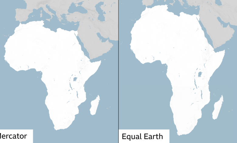
DAR ES SALAAM: THE United Nations decision to promote world maps that more accurately portray the size of continents could trigger a rethink of how geography is taught and understood in Tanzania.
The United Nations General Assembly on Friday overwhelmingly endorsed a resolution promoting the wider use of map projections that better represent the relative sizes of continents, particularly Africa.
The Togo-led initiative, backed by African countries, received 164 votes in favour, while six countries abstained and the United States was the only country to vote against it.
The resolution is not legally binding and does not ban the widely used Mercator projection. Instead, it encourages governments, schools, international organisations and technology companies to consider more accurate alternatives, including the Equal Earth projection.
For Tanzania, however, the significance of the move could go beyond how Africa appears on classroom walls.
Head of the Department of Geography at the University of Dar es Salaam (UDSM), Dr Nestory Yamungu, said the decision provided an opportunity for Tanzanians to rethink how they understand the geographical features around them and to strengthen scientific research into the country’s physical geography.
Speaking to the SUNDAY NEWS yesterday, Dr Yamungu welcomed the development, saying the long-standing Mercator projection had been criticised because it distorts the relative size of land masses, particularly those located towards the poles.
The Mercator projection, developed in the 16th century, remains widely used, particularly because of its usefulness for navigation. However, it makes areas at higher latitudes appear disproportionately large. As a result, Greenland can appear comparable in size to Africa on some maps, although Africa is about 14 times larger in area.
Dr Yamungu said the shift towards equal-area mapping should prompt Tanzania’s education sector to examine how geography is taught, particularly map-reading and map-drawing.
“For students, the learning system on map drawing will have to change by considering the fact that the new map suggests that even the current sizes of geographical features such as rivers, lakes and mountains that we inherited under the new map should be reviewed,” he said.
He said the development should encourage students to question information presented on maps and understand the difference between the actual size of a geographical feature and how it appears when represented on a twodimensional map.
For Tanzania, this could have implications for the teaching of the country’s lakes, rivers, mountains, islands and other physical features.
Dr Yamungu challenged Tanzanian academics to undertake more scientific research on geographical features rather than relying solely on historical documentation.
“The new map can push to new mapping of some areas,” he said. He argued that stronger geographical research could also contribute to better understanding and utilisation of Tanzania’s natural resources.
The goal remains the same: guess the hidden five-letter word within six attempts by using the color-coded feedback to narrow down the correct answer. Wordle Unlimited